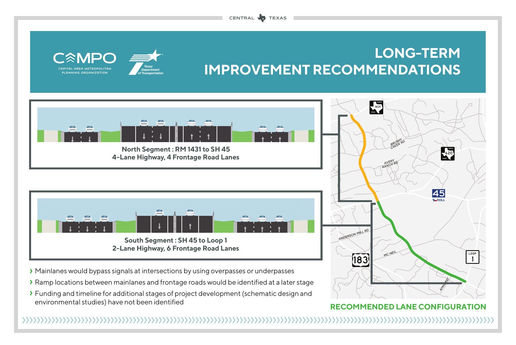
About 47,500 vehicles a day used Parmer Lane in 2024, according to exhibits from the third public open house of a state and regional corridor study. The study projects 66,042 a day by 2044, a 39% increase. The long-term fix it recommends for the stretch from MoPac to Cedar Park looks like a lot of Central Texas roads: highway main lanes that pass over or under the big intersections, with frontage roads on both sides.
Austin City Council will vote Thursday, Oct. 22, on whether to formally push back. Item 44, a resolution from Council Member Krista Laine, would make safety, walking, biking and transit the city’s priorities for any changes to Parmer. It would also ask the agencies to study a “complete-street” alternative in as much detail as the highway concepts and to do a full federal environmental review. Council members Vanessa Fuentes, Zohaib “Zo” Qadri, Mike Siegel and Paige Ellis are co-sponsors, according to the city’s agenda summary.
The vote won’t decide what gets built. Parmer is a state farm-to-market road (FM 734). The study is run by the Texas Department of Transportation and the Capital Area Metropolitan Planning Organization (CAMPO), the region’s federally designated transportation planning agency. The resolution would put the city’s position on the record while the plan is still a set of drawings. The study’s own exhibit says funding and a timeline for the next stages, schematic design and environmental studies, “have not been identified.”
The item is on the consent agenda, so it could pass in a single vote with dozens of other items unless a council member pulls it for discussion. Meeting Desk’s preview of the full Oct. 22 agenda covers the rest of the meeting.
What the study recommends
The study covers Parmer from Loop 1 (MoPac) in North Austin to RM 1431 (Whitestone Boulevard) in Cedar Park. It is one of 10 corridors in CAMPO’s Project Readiness Program, adopted in 2021, according to TxDOT’s study page, which says the road serves “tens of thousands of trips each day.”
Short-term proposals are mostly intersection work, such as signal changes and turn lanes, as the resolution describes them. The long-term choice is bigger. At the March 25 open house at Rattan Creek Community Center, the agencies showed four concepts. One kept Parmer as a six-lane road with intersections at street level. The other three added highway main lanes with frontage roads. All four included shared-use paths.
The recommended lane configuration splits the corridor in two:
- North segment, RM 1431 to SH 45: a four-lane highway with four frontage-road lanes.
- South segment, SH 45 to MoPac: a two-lane highway with six frontage-road lanes.
- Details still to come: Main lanes would bypass signals using overpasses or underpasses. Ramp locations “would be identified at a later stage.”
The agencies’ case: growth
The study’s case rests on growth, and the growth is real. The open-house exhibits cite Census and CAMPO 2050 plan figures:
- Williamson County: about 609,000 residents in 2020, projected to reach 1.7 million by 2050, a 179% increase.
- Travis County: 1.29 million projected to grow to 1.98 million, a 53% increase.
The exhibits also describe today’s road. It has two lanes in each direction from Whitestone to RM 620 and three from RM 620 to MoPac. Sidewalks and bike lanes are discontinuous, and a rail line crosses at street level north of RM 620. On that point, the agencies and the city agree: today’s Parmer falls short for people walking and biking. They disagree about the fix.
The city’s case: not another highway
The resolution’s argument is not that Parmer should stay as it is. It argues that a highway is the wrong fix for a road that runs past apartments, offices, shops, child care centers and neighborhood schools. Its main points:
- Northwest Austin already has highways: U.S. 183, the 183A Toll Road, SH 45 and MoPac. The resolution says turning Parmer into another would divide the neighborhoods it serves and could make it harder to walk, bike and reach places along it.
- Frontage roads have a worse safety record: The resolution says city crash records and TxDOT roadway data for 2019 to 2024 suggest frontage roads in Austin had about twice the rate of deadly and serious-injury crashes per mile driven as state-maintained arterial roads, and more than twice the rate on Parmer today. Those figures are the sponsors’ summary. The backup does not include the underlying analysis, and The Dispatch has not independently checked them.
- Students cross here: The resolution names routes to McNeil High School and Jollyville Elementary. It says faster, heavier traffic would raise children’s exposure to high-speed roads and to air pollution.
- A trail gap: Parmer between McNeil Drive and SH 45 is one of the few remaining gaps in the 36-mile Red Line Parkway walking and biking route. Two projects are planned to reach either end of that gap: Travis County’s Howard Lane Shared-Use Path and the city’s Red Line Trail from Lakeline Station to West Parmer Lane.
- City goals: The resolution cites the city’s goal, set in the Austin Strategic Mobility Plan, of cutting drive-alone trips to no more than half of all trips by 2039.
Residents have pushed in the same direction. The resolution says the Parmer Lane Alliance of Neighborhoods, a coalition from seven neighborhoods between MoPac and RM 620, signed a letter asking for several things:
- shared-use paths
- a fresh look at Parmer traffic once the U.S. 183 toll lanes are running
- attention to the McNeil Drive crossing used by McNeil High students
- a rethink of an “elevated superhighway next to residential areas”
Those lanes have since opened. The 183 North project’s news page shows its new express lanes opening in stages in early 2026. The traffic counts in the study’s March exhibits are from 2024, before they opened. The resolution also says neighbors submitted hundreds of comments raising concerns about grade separation and the lack of attention to other ways of getting around.
The study has asked for public input before. Its second open house, on Aug. 1, 2024, drew 55 people in person and 38 online and collected 71 surveys and 109 comments, according to the agencies’ summary.
What Council would ask for
If adopted, the resolution would direct the city manager to:
- Set standards for any plan. Short- or long-term, any plan should provide continuous sidewalks, trails and bike facilities. It should add signalized crossings or pedestrian beacons where crossings are far apart, starting with school routes. It should not increase vehicle miles traveled or greenhouse gas emissions, and it should keep new pavement, road widening and tree loss to a minimum.
- Set extra rules for the long-term design. A long-term design should have safe crossings at least every quarter-mile and no free-flowing turns or ramps across crosswalks, bike paths or sidewalks. Design and posted speeds should be no higher than 40 mph wherever there are driveways, crossings or homes and businesses next to the road. It should also show a reduction in deaths and serious injuries and add no traffic noise for neighbors.
- Ask for a real alternative. Before any concept advances to schematic design, CAMPO and TxDOT would be asked to study a complete-street option to the same level of detail as their recommended concepts.
- Request the missing numbers. The city would ask for the ramp locations assumed in the traffic model, the basis of the 2044 forecast, modeled travel times compared with doing nothing, speed assumptions and the safety analysis. The resolution calls these questions about the study’s technical analysis that “remain unanswered.”
- Push for the most thorough federal review. The city would press for an Environmental Impact Statement under the National Environmental Policy Act. That is the most detailed level of federal environmental review. TxDOT’s open house notice says environmental review for the project is carried out by TxDOT under a federal assignment agreement.
- Bring in partners. The city would work with CapMetro on transit lanes and stops for future bus service. It would also work with Round Rock ISD on student safety, especially at Parmer and McNeil Drive.
- Make it official and report back. The resolution would be sent to TxDOT and CAMPO as Council’s formal comments, and city staff would give Council a written update by March 31, 2027.
Why it matters
Austin’s growth has outpaced its roads, transit and trails, and Parmer shows it: a busy road that is hard to cross, with sidewalks that don’t connect. The open question is whose trips the fix is designed for. The highway concepts are built around through traffic. The resolution asks for designs judged by trips that start or end along the corridor, the commute to McNeil High, the walk to a bus stop, the bike ride to the Red Line trail, and not only by the drivers passing through.
Timing matters too. Once a concept moves to schematic design, alternatives get harder to bring back. Council’s resolution aims at that window, before ramp locations are chosen and before money is lined up.
What to watch
- Oct. 22: Council convenes at 10 a.m. at City Hall, 301 W. Second St. Public comment is allowed in person or by phone. Registration instructions are at the city’s Council Meeting Information Center.
- Corridor Summary Report: The open-house exhibits list a final summary report as the study’s next step. Any later phases would need more funding.
- The agencies’ response: Whether TxDOT and CAMPO agree to model a complete-street option, and whether they release the ramp, forecast and safety assumptions the resolution requests.
- March 31, 2027: Deadline for the city manager’s written update to Council.
Featured image: The “Long-Term Improvement Recommendations” exhibit from the Parmer Lane (FM 734) Corridor Study’s third public open house, March 2026. Exhibit by the Capital Area Metropolitan Planning Organization and the Texas Department of Transportation, a public record, via the study’s open house materials.